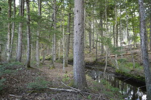
13.4 Acres Bass River, New Brunswick
This 13.4-acre parcel along Stephenson Road in Bass River offers a peaceful natural setting with year-round road access and electricity available at the roadside. A scenic brook runs through the land, and the rear boundary adjoins Crown land, creating a sense of space and privacy with plenty of room to explore the surrounding forest.

3.7-Acres Stephenson Road, Bass River, NB
Located in the rural community of Bass River, about an hour north of Moncton, this parcel offers year-round access via Stephenson Road, with electricity available at the roadside. A peaceful brook winds through the land — an excellent setting for rural living, a cabin getaway, or outdoor recreation.

3.9 Acres Cape Breton, Nova Scotia
Here is a great-sized lot located along Salem Road in the quiet Loch Lomond area of Cape Breton, Nova Scotia. The property offers excellent access, plenty of privacy, and close proximity to some of the region’s most beautiful lakes, all just 45 minutes from Sydney and 15 minutes from Bras d’Or Lake, Ben Eoin Golf, and the marina.

7 Acres Loch Lomond, Cape Breton
Here is a great sized lot located along Loch Lomond Road in the quiet Loch Lomond area of Cape Breton, Nova Scotia. Your property offers great access, plenty of privacy, and proximity to some of the region’s most beautiful lakes.
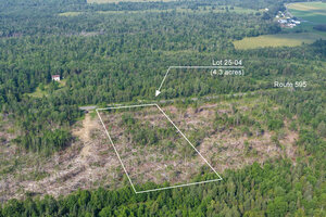
4.3-Acres Waterville, New Brunswick
Here is a great-sized building and recreation lot located in Central Waterville - 15 minutes from the town of Nackawic and the Saint John River, and one hour from the city of Fredericton. road front and access along Route 595 with electricity and phone service.
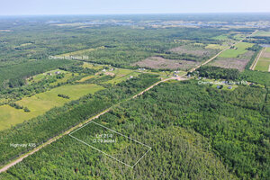
2.79 acres Saint-Fabien, NB - Lot 9 Route 495
Here is a fantastic property in Saint-Fabien along Route 495. Location is excellent – a nice community and a spacious property just a few kilometres north of Sainte-Marie de Kent and the Bouctouche River. Treed throughout. Electricity and phone service are available.
Lot 24-15 - Melanson Road Notre Dame
This 5-acre lot on Melanson Road in Notre Dame offers an ideal location for residential use and recreation. Located under 20 minutes from the city of Moncton, you’ll enjoy the privacy of country living while remaining close to amenities. This lot is an excellent choice for building your dream home or creating a peaceful retreat in the heart of nature.

7.6 Acres in Notre Dame. 20 minutes from Moncton.
This 7.6-acre lot on Melanson Road in Notre Dame offers an ideal location for residential use. Located under 20 minutes from the city of Moncton, you’ll enjoy the privacy of country living while remaining close to amenities. This lot is an excellent choice for building your dream home or creating a peaceful retreat in the heart of nature.
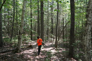
4.15 Acres Forested Lot by Miller Brook
Situated along Green Road, in the rural landscape of Elgin, this charming 4.15-acre lot is bordered by the peaceful flow of Miller Brook. With its mature forest, this property offers a perfect blend of privacy and natural beauty. Just a short drive to Elgin and within 15 minutes of Petitcodiac, it’s an ideal spot for your quiet rural getaway or an outdoor retreat.
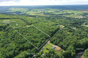
7.8 Acres in Elgin, New Brunswick
Here is a beautiful 7.8 acre lot situated along the River Road in Elgin, New Brunswick. Parcel B, with 492 feet offers both natural beauty and development potential. You are just around the corner from the Pollett River and its refreshing river pools. The recreation trail system for ATVs and snowmobiles is also nearby. This is a great place to live and own land if you enjoy a laid-back lifestyle and escape from the city.